
Related Images


This image was acquired from
wikimedia. It was marked as Public Domain or CC0 and is free to use. To verify, go to the source and check the information there.
Looking for more info about this image?
Try a Google Reverse Image Search for it.
Try a Google Reverse Image Search for it.
Keywords from Image Description:
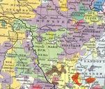
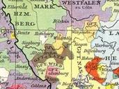
Sayn Map. Karte der Grafschaften Sayn Wied Isenburg Runkel und Wittgenstein aus Droysens Historischer Handatlas Fotograf Droysen Th Lindner Datum Map of the counties of Sayn Wied Isenburg Runkel and Wittgenstein from Droysens Historischer Handatlas Illustrator Droysen Th Lindner date VereinigteHerzogtuemer UTC VereinigteHerzogtuemer