
Related Images


Download:
| Tiny | 145x128 | View | Download |
| Small | 291x256 | View | Download |
| Medium | 582x512 | View | Download |
| Large | 1164x1024 | View | Download |
| Original | 5500x4837 | View | Download |
This image was acquired from
wikimedia. It was marked as Public Domain or CC0 and is free to use. To verify, go to the source and check the information there.
Looking for more info about this image?
Try a Google Reverse Image Search for it.
Try a Google Reverse Image Search for it.
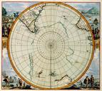
Keywords from Image Description:
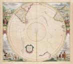
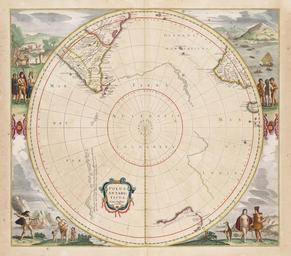
map Polus Antarcticus. en Map of the southern polar regions Polus Antarcticus cum regionibus subjacentibus et maribus illum alluentibus The Antarctic pole with the adjoining regions and seas flowing near it From Atlantis majoris quinta pars the fifth part of the Atlas Major by Jan Janssonius geheugenvannederland nl language