
Related Images


Download:
| Tiny | 177x128 | View | Download |
| Small | 355x256 | View | Download |
| Medium | 711x512 | View | Download |
| Large | 1423x1024 | View | Download |
| Original | 6000x4317 | View | Download |
This image was acquired from
wikimedia. It was marked as Public Domain or CC0 and is free to use. To verify, go to the source and check the information there.
Looking for more info about this image?
Try a Google Reverse Image Search for it.
Try a Google Reverse Image Search for it.
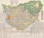
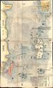
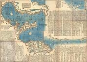
Keywords from Image Description:
Japanese Edo Period Woodblock Map of the Izu Islands Tokyo or Edo Geographicus IsuIslandsjapanese. An extraordinary find this is Tokugawa Period Japanese woodblock nautical chart of the Izu Islands Izushoto Oriented to the East this map covers from Chiba Kanagawa and Sagami Bay southwards as far as Miyake and Mikurajima Islands