
Related Images


Download:
| Tiny | 103x128 | View | Download |
| Small | 207x256 | View | Download |
| Medium | 415x512 | View | Download |
| Large | 831x1024 | View | Download |
| Original | 3247x4000 | View | Download |
This image was acquired from
wikimedia. It was marked as Public Domain or CC0 and is free to use. To verify, go to the source and check the information there.
Looking for more info about this image?
Try a Google Reverse Image Search for it.
Try a Google Reverse Image Search for it.
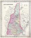
Keywords from Image Description:
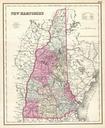
Colton Map of New Hampshire Geographicus NewHampshirecolton. One of the few maps specifically of New Hampshire published in the mid th century Depicts the state in full with superb detail regarding the cities transportation system geographical features and counties Prepared by Colton for inclusion as plate no in the issue of