
Related Images


Download:
| Tiny | 120x128 | View | Download |
| Small | 241x256 | View | Download |
| Medium | 482x512 | View | Download |
| Large | 964x1024 | View | Download |
| Original | 2028x2152 | View | Download |
This image was acquired from
flickr. It was marked as Public Domain or CC0 and is free to use. To verify, go to the source and check the information there.
Looking for more info about this image?
Try a Google Reverse Image Search for it.
Try a Google Reverse Image Search for it.
Keywords from Image Description:
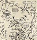
map cartoon drawing sketch writing text print pattern document texture Map of Pearl Harbor Hawaii during the first six months of the Pacific war released in connection with the publication of Battle Report by Commander Walter Karig USNR and Lieutenant Welborne Kelley USNR. This map shows the approximate position of ships on December