
Related Images


Download:
| Tiny | 79x128 | View | Download |
| Small | 159x256 | View | Download |
| Medium | 319x512 | View | Download |
| Large | 639x1024 | View | Download |
| Original | 4333x6941 | View | Download |
This image was acquired from
wikimedia. It was marked as Public Domain or CC0 and is free to use. To verify, go to the source and check the information there.
Looking for more info about this image?
Try a Google Reverse Image Search for it.
Try a Google Reverse Image Search for it.
Keywords from Image Description:
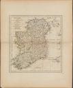
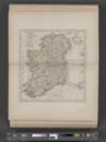
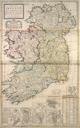
A new map of Ireland divided into its provinces counties and baronies wherein are distinguished the bishopricks borroughs barracks bogs passes bridges c. with the principal roads and the NYPL b. en Date based on latest dated map map of London bound near end NN Citation Variant of Phillips Lawrence Slaughter Collection NYPL copy