
Related Images


Download:
| Tiny | 165x128 | View | Download |
| Small | 330x256 | View | Download |
| Medium | 661x512 | View | Download |
| Large | 1323x1024 | View | Download |
| Original | 5700x4411 | View | Download |
This image was acquired from
wikimedia. It was marked as Public Domain or CC0 and is free to use. To verify, go to the source and check the information there.
Looking for more info about this image?
Try a Google Reverse Image Search for it.
Try a Google Reverse Image Search for it.
Keywords from Image Description:
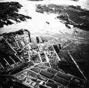
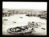
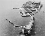
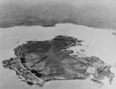
Aerial view of Ford Island Hawaii in the s. Aerial view of Ford Island Pearl Harbor Territory of Hawaii circa midtolate showing the approximate boundary between the Navy and the Army bases The flying field thought owned by the Army was used by both services Official Navy photo history navy mil html html NH from the Navy history