
Related Images


Download:
| Tiny | 168x128 | View | Download |
| Small | 337x256 | View | Download |
| Medium | 674x512 | View | Download |
| Large | 1348x1024 | View | Download |
| Original | 2400x1823 | View | Download |
This image was acquired from
wikimedia. It was marked as Public Domain or CC0 and is free to use. To verify, go to the source and check the information there.
Looking for more info about this image?
Try a Google Reverse Image Search for it.
Try a Google Reverse Image Search for it.
Keywords from Image Description:
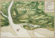
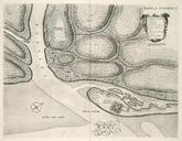
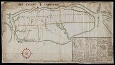
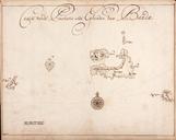
AMHNA Map of Itamaraca Island. Artwork nl Kaart van het Eiland Itamaraca nl Kaart van het Eiland Itamaraca Titel in de Catalogus Leupe NA aart van het Eylandt Tamaricke aan de Custe van Bresilien leggende op seven graden ende een halve Teijlant Tamaricke aen de Custe van Bresilien leggende op seuwen graden ende een halve Legenda