
Related Images


Download:
| Tiny | 118x128 | View | Download |
| Small | 237x256 | View | Download |
| Medium | 475x512 | View | Download |
| Large | 950x1024 | View | Download |
| Original png | 1062x1144 | View | Download |
| Original as jpg | 1062x1144 | View | Download |
This image was acquired from
wikimedia. It was marked as Public Domain or CC0 and is free to use. To verify, go to the source and check the information there.
Looking for more info about this image?
Try a Google Reverse Image Search for it.
Try a Google Reverse Image Search for it.
Keywords from Image Description:
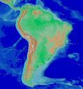
Andes. Andes Americanos free data depot arcGIS quantum GIS Created with Quantum GIS Carlos Arango All Topographic maps of South America Maps of the Andes