
Related Images


Download:
| Tiny | 255x128 | View | Download |
| Small | 511x256 | View | Download |
| Medium | 1023x512 | View | Download |
| Large | 2047x1024 | View | Download |
| Original | 2505x1253 | View | Download |
This image was acquired from
wikimedia. It was marked as Public Domain or CC0 and is free to use. To verify, go to the source and check the information there.
Looking for more info about this image?
Try a Google Reverse Image Search for it.
Try a Google Reverse Image Search for it.
Keywords from Image Description:
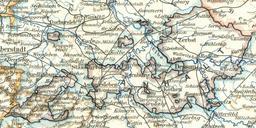
Anhalt. Karte von Anhalt aus dem Jahr Alle zu Anhalt gehrigen Gebiete sind schwarz umrandet Quelle Meyers KonversationsLexikon fnfte Auflage Fnfzehnter Band Leipzig Ausschnitt aus der Karte Provinz Sachsen und Anhalt PDold Maps of Anhalt Old maps of SaxonyAnhalt Maps of Saxony Province