
Related Images


Download:
| Tiny | 128x128 | View | Download |
| Small | 256x256 | View | Download |
| Medium | 512x512 | View | Download |
| Large | 1024x1024 | View | Download |
| Original | 3930x3930 | View | Download |
This image was acquired from
wikimedia. It was marked as Public Domain or CC0 and is free to use. To verify, go to the source and check the information there.
Looking for more info about this image?
Try a Google Reverse Image Search for it.
Try a Google Reverse Image Search for it.
Keywords from Image Description:
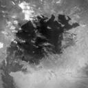
AralSeaAugkeyhole. This image of the Aral Sea was acquired in August of by United States Argon intelligence mapping satellite KH Mission incorrectly mislabeled in the USGS archive carried the mapping camera TATAgena carried this camera into an orbit of degrees of inclination with period of minutes perigee of degrees and an apogee