
Related Images


Download:
| Tiny | 188x128 | View | Download |
| Small | 377x256 | View | Download |
| Medium | 754x512 | View | Download |
| Large | 1508x1024 | View | Download |
| Original | 4832x3280 | View | Download |
This image was acquired from
wikimedia. It was marked as Public Domain or CC0 and is free to use. To verify, go to the source and check the information there.
Looking for more info about this image?
Try a Google Reverse Image Search for it.
Try a Google Reverse Image Search for it.
Keywords from Image Description:
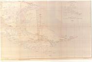
Arbitration. This partially reproduced map correspond to the called 'Preliminary Map of the Southern Region of the Argentine Republic'which was included as No XIV in the Argentine Evidence submitted by the Argentine Government to British Arbitration in It is the first official map of Argentina showing in the area of the Beagle Channel