
Related Images


This image was acquired from
wikimedia. It was marked as Public Domain or CC0 and is free to use. To verify, go to the source and check the information there.
Looking for more info about this image?
Try a Google Reverse Image Search for it.
Try a Google Reverse Image Search for it.
Keywords from Image Description:
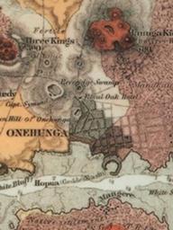
AucklandMapHochstetter Onehunga crop. Onehunga and nearby volcanoes Portion of map of the Auckland Volcanic Field by Ferdinand von Hochstetter Originally published in Geologischtopographischer Atlas von NeuSeeland Hochstetter and Petermann and republished in English in Original downloaded from gsnz org nz Another scan is available