Related Images


Download:
| Tiny | 182x128 | View | Download |
| Small | 364x256 | View | Download |
| Medium | 728x512 | View | Download |
| Large | 1457x1024 | View | Download |
| Original tiff | 6400x4498 | View | Download |
| Original as jpg | 6400x4498 | View | Download |
This image was acquired from
wikimedia. It was marked as Public Domain or CC0 and is free to use. To verify, go to the source and check the information there.
Looking for more info about this image?
Try a Google Reverse Image Search for it.
Try a Google Reverse Image Search for it.
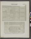
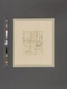
Keywords from Image Description:
Aurelius Township NYPL. atlas ill colored maps fold cm Map Div New York State Beers County atlas of Cayuga New York updated nypl org cfm imageID nypl org Atlases of the United States New York County atlas of Cayuga New York From recent and actual surveys and records under the superintendence of Beers Stephen Schwarzman