
Related Images


Download:
| Tiny | 128x128 | View | Download |
| Small | 256x256 | View | Download |
| Medium | 512x512 | View | Download |
| Large | 1024x1024 | View | Download |
| Original | 1200x1200 | View | Download |
This image was acquired from
wikimedia. It was marked as Public Domain or CC0 and is free to use. To verify, go to the source and check the information there.
Looking for more info about this image?
Try a Google Reverse Image Search for it.
Try a Google Reverse Image Search for it.
Keywords from Image Description:
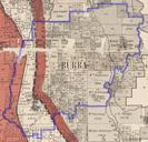
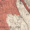
Australian Capital Territory border Murray Cowley . Map showing the only part of the ACT border to be determined by property boundaries small section in the south east between the QueanbeyanCooma railway line and the eastern watershed of Gudgenby River The ACT is highlighted in red The red line in the top right is proposed addition