
Related Images


Download:
| Tiny | 180x128 | View | Download |
| Small | 361x256 | View | Download |
| Medium | 722x512 | View | Download |
| Original | 1195x847 | View | Download |
This image was acquired from
wikimedia. It was marked as Public Domain or CC0 and is free to use. To verify, go to the source and check the information there.
Looking for more info about this image?
Try a Google Reverse Image Search for it.
Try a Google Reverse Image Search for it.
Keywords from Image Description:
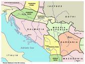
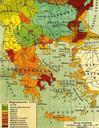
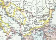
Balkans in th century. Map of the Balkans part of Byzantine Empire taken from Droysens Allgemeiner Historischer Handatlas Verlag Velhagen und Klasing Droysens Allgemeiner Historischer Handatlas Verlag Velhagen und Klasing Bielefeld Leipzig November UTC Professor Gustav Droysen Hg Professor Hertzberg Zeichnung This image is