
Related Images


Download:
| Tiny | 202x128 | View | Download |
| Small | 405x256 | View | Download |
| Medium | 810x512 | View | Download |
| Original png | 1000x632 | View | Download |
| Original as jpg | 1000x632 | View | Download |
This image was acquired from
wikimedia. It was marked as Public Domain or CC0 and is free to use. To verify, go to the source and check the information there.
Looking for more info about this image?
Try a Google Reverse Image Search for it.
Try a Google Reverse Image Search for it.
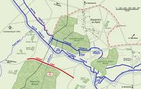
Keywords from Image Description:
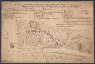
Bazentin le Petit July map. Ataque de la Divisin Britnica sobre Bazentin le Petit de julio de El terreno capturado las de la maana est delimitado por la lnea roja discontinua Map of Bazentin le Petit sector on the morning of July Battle of Bazentin Ridge showing the German second defensive position German trenches are shown