
Related Images


Download:
| Tiny | 90x128 | View | Download |
| Small | 180x256 | View | Download |
| Medium | 361x512 | View | Download |
| Large | 722x1024 | View | Download |
| Original | 2500x3542 | View | Download |
This image was acquired from
wikimedia. It was marked as Public Domain or CC0 and is free to use. To verify, go to the source and check the information there.
Looking for more info about this image?
Try a Google Reverse Image Search for it.
Try a Google Reverse Image Search for it.
Keywords from Image Description:
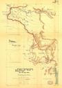
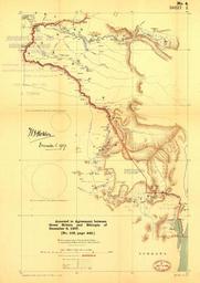
Ca. en Map of the frontier between British East Africa Protectorate in Uganda and Abyssinia Sir Hertslet The map of Africa by treaty ed London Printed for Stationery off by Harrison and sons loc gov gmd gct Unknown but obviously died more than years ago British East Africa Map Maps of the history of Ethiopia Maps of the history