
Related Images


Download:
| Tiny | 201x128 | View | Download |
| Small | 402x256 | View | Download |
| Medium | 805x512 | View | Download |
| Original | 908x577 | View | Download |
This image was acquired from
wikimedia. It was marked as Public Domain or CC0 and is free to use. To verify, go to the source and check the information there.
Looking for more info about this image?
Try a Google Reverse Image Search for it.
Try a Google Reverse Image Search for it.
Keywords from Image Description:
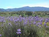
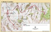
Caliente Corridor. Map of the proposed Caliente Corridor route for transportation of spent nuclear fuel The northwest portion of the Amargosa Desert starts at the mountains at the southeast of the Sarcobatus Flat Office of Civilian Radioactive Waste Management Department of Energy BSC Transportation badJPEG PDUSGov Check categories