
Related Images


Download:
| Tiny | 83x128 | View | Download |
| Small | 166x256 | View | Download |
| Medium | 333x512 | View | Download |
| Large | 666x1024 | View | Download |
| Original | 1308x2011 | View | Download |
This image was acquired from
wikimedia. It was marked as Public Domain or CC0 and is free to use. To verify, go to the source and check the information there.
Looking for more info about this image?
Try a Google Reverse Image Search for it.
Try a Google Reverse Image Search for it.
Keywords from Image Description:
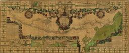
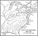
Canal do Cassiquiare. Map of the Cassiquiare channel natural waterway connecting the rivers Orinoco and Negro in the Amazonas forest The map was drafted based on Alexander von Humboldt survey of the area The longitudes are about degrees higher based on the Paris meridian PDold Old maps of Brazil Old maps of the history of Venezuela