
Related Images


Download:
| Tiny | 175x128 | View | Download |
| Small | 351x256 | View | Download |
| Medium | 702x512 | View | Download |
| Large | 1404x1024 | View | Download |
| Original | 9391x6847 | View | Download |
This image was acquired from
wikimedia. It was marked as Public Domain or CC0 and is free to use. To verify, go to the source and check the information there.
Looking for more info about this image?
Try a Google Reverse Image Search for it.
Try a Google Reverse Image Search for it.
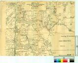
Keywords from Image Description:
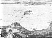
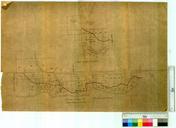
Canning Contour Channel plan . LargeImage Preconstruction map of the Canning Contour Channel dated Prepared by MWSS DD Metropolitan Water Supply and Drainage Department later taken over by the Public Works Department Western Australia PDAustralia Canning Contour Channel Values notated on each property are possibly land resumption