
Related Images


Download:
| Tiny | 153x128 | View | Download |
| Small | 307x256 | View | Download |
| Medium | 614x512 | View | Download |
| Original png | 984x820 | View | Download |
| Original as jpg | 984x820 | View | Download |
This image was acquired from
wikimedia. It was marked as Public Domain or CC0 and is free to use. To verify, go to the source and check the information there.
Looking for more info about this image?
Try a Google Reverse Image Search for it.
Try a Google Reverse Image Search for it.
Keywords from Image Description:
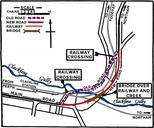
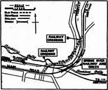
Clackline Bridge map . en plan from showing the location of the thennew overhead bridge over the gully at Clackline Western Australia to be opened by the ActingMinister for Works Mr Millington new portion of the main road between Perth and Northam was constructed to serve the bridge and avoid dangerous deviation and two railway