
Related Images


Download:
| Tiny | 98x128 | View | Download |
| Small | 196x256 | View | Download |
| Medium | 393x512 | View | Download |
| Large | 786x1024 | View | Download |
| Original | 3144x4096 | View | Download |
This image was acquired from
wikimedia. It was marked as Public Domain or CC0 and is free to use. To verify, go to the source and check the information there.
Looking for more info about this image?
Try a Google Reverse Image Search for it.
Try a Google Reverse Image Search for it.
Keywords from Image Description:
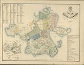
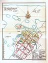
Claes Claesson Map Oulu . An old map of Oulu Finland was drawn by Claes Claesson in The rectangular street layout plan is done with red colour Claes Claessonin vuonna piirtm kartta Oulusta Ruutukaavaa on jo hahmoteltu punaisella Virkkunen Oulun kaupungin historia Kirjola Oy scanned by Estormiz February UTC Original Source