
Related Images


Download:
| Tiny | 103x128 | View | Download |
| Small | 206x256 | View | Download |
| Medium | 413x512 | View | Download |
| Original | 540x669 | View | Download |
This image was acquired from
wikimedia. It was marked as Public Domain or CC0 and is free to use. To verify, go to the source and check the information there.
Looking for more info about this image?
Try a Google Reverse Image Search for it.
Try a Google Reverse Image Search for it.
Keywords from Image Description:
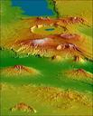
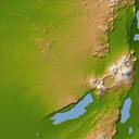
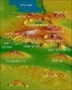
CraterHighlands Tanzania NASAhe. Topographical map of the Crater Highlands in Tanzania Color indicates height with lowest elevations in green and highest elevations in white Shading shows the slope The vertical relief has been exaggerated by factor of to reveal greater detail about the landscape The image is oriented as though you