
Related Images


Download:
| Tiny | 128x128 | View | Download |
| Small | 256x256 | View | Download |
| Original png | 425x425 | View | Download |
| Original as jpg | 425x425 | View | Download |
This image was acquired from
wikimedia. It was marked as Public Domain or CC0 and is free to use. To verify, go to the source and check the information there.
Looking for more info about this image?
Try a Google Reverse Image Search for it.
Try a Google Reverse Image Search for it.
Keywords from Image Description:
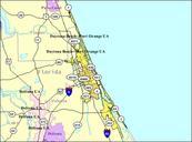
Daytonaportorangefluacropped. en Cropped Map of the Daytona Beach Port Orange FL Urbanized Area as defined by the United States Census Bureau Part of Atlantic Ocean has been cropped out of original image to improve display org Daytonaportorangeflua Gamweb February PDUSGov Urbanized Areas in Florida Original upload log bytes