
Related Images


Download:
| Tiny | 114x128 | View | Download |
| Small | 229x256 | View | Download |
| Medium | 459x512 | View | Download |
| Large | 918x1024 | View | Download |
| Original | 2154x2401 | View | Download |
This image was acquired from
wikimedia. It was marked as Public Domain or CC0 and is free to use. To verify, go to the source and check the information there.
Looking for more info about this image?
Try a Google Reverse Image Search for it.
Try a Google Reverse Image Search for it.
Keywords from Image Description:
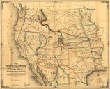
De Smet Council Bluffs. en April en small portion of PierreJean De Smet's map of the Council Bluffs Region traced by the contributor The area labeled Caldwell's Camp was probably near or just southeast of Broadway the Fish Pond is Big Lake Park and St Joseph's was the Council Bluffs blockhouse The original maps are on file in