
Related Images


Download:
| Tiny | 100x128 | View | Download |
| Small | 201x256 | View | Download |
| Medium | 402x512 | View | Download |
| Large | 804x1024 | View | Download |
| Original png | 1300x1655 | View | Download |
| Original as jpg | 1300x1655 | View | Download |
This image was acquired from
wikimedia. It was marked as Public Domain or CC0 and is free to use. To verify, go to the source and check the information there.
Looking for more info about this image?
Try a Google Reverse Image Search for it.
Try a Google Reverse Image Search for it.
Keywords from Image Description:
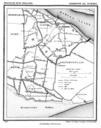
Den Bommel . Historic map of Den Bommel now part of municipality Oostflakkee South Holland the Netherlands Gemeente Atlas van Nederland Municipal Atlas of the Netherlands Kuyper PDold Gemeente Atlas van Nederland South Holland Oostflakkee Den Bommel