
Related Images


Download:
| Tiny | 51x128 | View | Download |
| Small | 102x256 | View | Download |
| Medium | 205x512 | View | Download |
| Original svg | 210x524 | View | Download |
| Original as jpg | 210x524 | View | Download |
This image was acquired from
wikimedia. It was marked as Public Domain or CC0 and is free to use. To verify, go to the source and check the information there.
Looking for more info about this image?
Try a Google Reverse Image Search for it.
Try a Google Reverse Image Search for it.
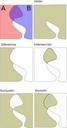
Keywords from Image Description:
Digitizing errors.svg en Topological and digitizing errors in Geography Information Systems GIS es Errores topolgicos de digitalizacin en Sistemas de Informacin Geogrfica SIG own Tony Rotondas Geographic information systems Computer errors