
Related Images


Download:
| Tiny | 176x128 | View | Download |
| Small | 353x256 | View | Download |
| Medium | 707x512 | View | Download |
| Large | 1415x1024 | View | Download |
| Original | 4944x3576 | View | Download |
This image was acquired from
wikimedia. It was marked as Public Domain or CC0 and is free to use. To verify, go to the source and check the information there.
Looking for more info about this image?
Try a Google Reverse Image Search for it.
Try a Google Reverse Image Search for it.
Keywords from Image Description:
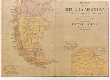
DouclotNolte.. Map of the Argentine Republic and neighbouring Countries The map partially reproduced here wasdrawn up in Buenos Aires in by Duclout and published by Nolte In the southern region the international boundary is shown traced through the centre of the Beagle channel continuing beyond the eastern mouth of the Channel