
Related Images


Download:
| Tiny | 116x128 | View | Download |
| Small | 232x256 | View | Download |
| Original png | 393x432 | View | Download |
| Original as jpg | 393x432 | View | Download |
This image was acquired from
wikimedia. It was marked as Public Domain or CC0 and is free to use. To verify, go to the source and check the information there.
Looking for more info about this image?
Try a Google Reverse Image Search for it.
Try a Google Reverse Image Search for it.
Keywords from Image Description:
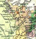
Dri Bistmer. Map of the Three Bishoprics showing their annexation to Early Modern France Troisvchs Situatioun vun den dri Bistmer lib utexas edu France Extension of the French Frontiers The Historical Atlas by William Shepherd lib utexas edu PerryCastaeda map collection August UTC OwenBlacker br Original uploader was