
Related Images


Download:
| Tiny | 192x128 | View | Download |
| Small | 384x256 | View | Download |
| Medium | 768x512 | View | Download |
| Large | 1536x1024 | View | Download |
| Original | 5760x3840 | View | Download |
This image was acquired from
wikimedia. It was marked as Public Domain or CC0 and is free to use. To verify, go to the source and check the information there.
Looking for more info about this image?
Try a Google Reverse Image Search for it.
Try a Google Reverse Image Search for it.
Keywords from Image Description:
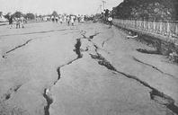
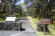
Earthquake Trail. en Earthquake Trail was formerly section of Crater Rim Drive until November At magnitude earthquake under the east flank of Mauna Loa caused portions of the road to collapse into the caldera nps gov htm id ADEDEFBCDD Michael Szoenyi These photos are public domain Please use credits listed under photos