
Related Images


Download:
| Tiny | 176x128 | View | Download |
| Small | 353x256 | View | Download |
| Medium | 706x512 | View | Download |
| Large | 1413x1024 | View | Download |
| Original | 15705x11378 | View | Download |
This image was acquired from
wikimedia. It was marked as Public Domain or CC0 and is free to use. To verify, go to the source and check the information there.
Looking for more info about this image?
Try a Google Reverse Image Search for it.
Try a Google Reverse Image Search for it.
Keywords from Image Description:
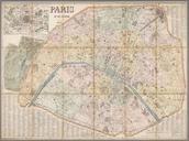
Eduard DumasVorzet Paris et ses environs . Map of Paris in Includes insets Environs de Paris and Plan des tramways Scale map hand colored Size cm Institution LOC object history exhibition history credit line LOCmap gp ct accession number PD Maps of Paris in the th century thcentury maps of Paris Old locator maps of arrondissements