
Related Images


Download:
| Tiny | 128x128 | View | Download |
| Small | 256x256 | View | Download |
| Medium | 512x512 | View | Download |
| Original png | 850x850 | View | Download |
| Original as jpg | 850x850 | View | Download |
This image was acquired from
wikimedia. It was marked as Public Domain or CC0 and is free to use. To verify, go to the source and check the information there.
Looking for more info about this image?
Try a Google Reverse Image Search for it.
Try a Google Reverse Image Search for it.
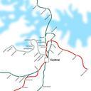
Keywords from Image Description:
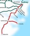
ESI downtown map. This is map of the Eastern Suburbs Illawarra Line in Sydney Australia in red traced on this public domain map Original edit by NE own assumed NE Maps of New South Wales railways Eastern Suburbs railway line New South Wales Light rail in Sydney