
Related Images


Download:
| Tiny | 257x128 | View | Download |
| Small | 514x256 | View | Download |
| Medium | 1028x512 | View | Download |
| Large | 2057x1024 | View | Download |
| Original | 5000x2488 | View | Download |
This image was acquired from
wikimedia. It was marked as Public Domain or CC0 and is free to use. To verify, go to the source and check the information there.
Looking for more info about this image?
Try a Google Reverse Image Search for it.
Try a Google Reverse Image Search for it.
Keywords from Image Description:
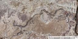
Exhumed Paleochannel Emery County Utah. en Exhumed fluvial paleochannel Emery County Utah The erosion of softer surrounding mudstone left this paleochannel as sandstone ridge Created from USDA Aerial Photography Field Office NAIP digital aerial orthophoto mosaic for Emery County Utah latitude longitude USDA USDA PDUSGov