
Related Images


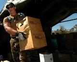


Download:
| Tiny | 173x128 | View | Download |
| Small | 347x256 | View | Download |
| Medium | 695x512 | View | Download |
| Large | 1391x1024 | View | Download |
| Original | 5653x4159 | View | Download |
This image was acquired from
wikimedia. It was marked as Public Domain or CC0 and is free to use. To verify, go to the source and check the information there.
Looking for more info about this image?
Try a Google Reverse Image Search for it.
Try a Google Reverse Image Search for it.
Keywords from Image Description:
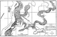
FortPemberton. en Opposing forces near Greenwood Mississippi in the Yazoo Pass Expedition of the American Civil War March Own Kloeppel Own work This map is derived from maps prepared by or for the US Government one for Gen Loring CSA Official military atlas Plate the other for Lt Col Wilson USA Official records Army ser Maps