
Related Images


Download:
| Tiny | 128x128 | View | Download |
| Original png | 246x246 | View | Download |
| Original as jpg | 246x246 | View | Download |
This image was acquired from
wikimedia. It was marked as Public Domain or CC0 and is free to use. To verify, go to the source and check the information there.
Looking for more info about this image?
Try a Google Reverse Image Search for it.
Try a Google Reverse Image Search for it.
Keywords from Image Description:
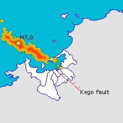
Fukuoka Quake Seismicity KegoDansou. Map of Fukuoka City showing epicentre of March th quake and rough map of subsequent seismic activity along with location of the Kego fault Made using data from sevo kyushuu ac jp html and maps from Japanese with the Gimp own work User Oarih Maps of Fukuoka Fukuoka earthquake