
Related Images


Download:
| Tiny | 86x128 | View | Download |
| Small | 173x256 | View | Download |
| Medium | 347x512 | View | Download |
| Large | 694x1024 | View | Download |
| Original | 749x1105 | View | Download |
This image was acquired from
wikimedia. It was marked as Public Domain or CC0 and is free to use. To verify, go to the source and check the information there.
Looking for more info about this image?
Try a Google Reverse Image Search for it.
Try a Google Reverse Image Search for it.
Keywords from Image Description:
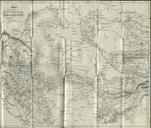
General Austin Map of Texas. en Printed on the map Map of Texas with parts of the adjoining states Note The latitude and longitude of Saltillo Monterey Laredo Bexar Nachodoches and the point where the boundary line leaves the Sabine are from the observations of General Teran of the Mexican Army Engraved by John Wm Warr Philadelphia