
Related Images


Download:
| Tiny | 232x128 | View | Download |
| Small | 464x256 | View | Download |
| Medium | 928x512 | View | Download |
| Large | 1857x1024 | View | Download |
| Original | 12468x6873 | View | Download |
This image was acquired from
wikimedia. It was marked as Public Domain or CC0 and is free to use. To verify, go to the source and check the information there.
Looking for more info about this image?
Try a Google Reverse Image Search for it.
Try a Google Reverse Image Search for it.
Keywords from Image Description:
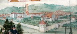
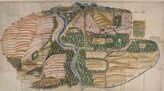
Hans Caspar Knoder Landtafel der Gemarkung Kuppenheim . LargeImage Die Gemarkung der Stadt Kuppenheim Landtafelkarte von Hans Caspar Knoder GLAK Kuppenheim Der Fluss ist die Murg zwischen Kuppenheim und Rauental in der Rheinebene hinten der Rand des Schwarzwalds mit den Schlssern Hohenbaden und Alteberstein Die Karte ist im Orignal