
Related Images


Download:
| Tiny | 135x128 | View | Download |
| Small | 270x256 | View | Download |
| Medium | 541x512 | View | Download |
| Large | 1082x1024 | View | Download |
| Original | 2641x2498 | View | Download |
This image was acquired from
wikimedia. It was marked as Public Domain or CC0 and is free to use. To verify, go to the source and check the information there.
Looking for more info about this image?
Try a Google Reverse Image Search for it.
Try a Google Reverse Image Search for it.
Keywords from Image Description:
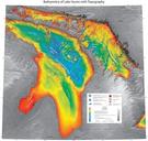
Huron. en Annotated Bathymetry Map of Lake Huron showing subsurface ridges labelled This image is necessary to show ridge areas under water and under research NOAA National Centers For Environmental Information National Oceanic and Atmospheric Administration by Right of the United States of America other versions PDUSGov Great Lakes