
Related Images

Download:
| Tiny | 99x128 | View | Download |
| Small | 198x256 | View | Download |
| Medium | 397x512 | View | Download |
| Large | 795x1024 | View | Download |
| Original | 1154x1485 | View | Download |
This image was acquired from
wikimedia. It was marked as Public Domain or CC0 and is free to use. To verify, go to the source and check the information there.
Looking for more info about this image?
Try a Google Reverse Image Search for it.
Try a Google Reverse Image Search for it.
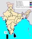
Keywords from Image Description:
Indiamap. en This is the political map of India in The yellow portion shown here is the Maratha Empire The Public Schools Historical Atlas by Charles Colbeck Longmans Green New York London Bombay Charles Colbeck PDscan Uploaded with Old maps of the Indian Subcontinent Maps of the Maratha Confederacy Maps showing thcentury history