
Related Images


This image was acquired from
wikimedia. It was marked as Public Domain or CC0 and is free to use. To verify, go to the source and check the information there.
Looking for more info about this image?
Try a Google Reverse Image Search for it.
Try a Google Reverse Image Search for it.
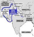
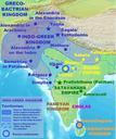
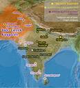
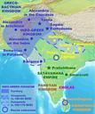
Keywords from Image Description:
IndoGreekKingdomMap. Per Honor et Gloria en Maximum extent of IndoGreek territory circa BC Map drawn by User PHG based on Referenced material in the IndoGreek Kingdom article other versions en Clpo MTC BadJPEG PDuseren Per Honor et Gloria October Original upload log page en IndoGreekKingdomMap Per Honor et Gloria Better