
Related Images


Download:
| Tiny | 191x128 | View | Download |
| Small | 382x256 | View | Download |
| Original png | 433x290 | View | Download |
| Original as jpg | 433x290 | View | Download |
This image was acquired from
wikimedia. It was marked as Public Domain or CC0 and is free to use. To verify, go to the source and check the information there.
Looking for more info about this image?
Try a Google Reverse Image Search for it.
Try a Google Reverse Image Search for it.
Keywords from Image Description:
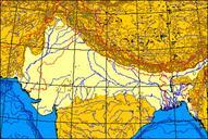
IndoGangeticPlain Map. Map of the IndoGangetic Plain produced this map myself using the program aquarius geomar de html here and modifying it It remains in the public domain The map is an azimuthal equalarea projection The Line of Control through Kashmir is green Where the line of control along the IndoChinese frontier coincides