
Related Images


Download:
| Tiny | 197x128 | View | Download |
| Small | 395x256 | View | Download |
| Medium | 791x512 | View | Download |
| Large | 1582x1024 | View | Download |
| Original | 2550x1650 | View | Download |
This image was acquired from
flickr. It was marked as Public Domain or CC0 and is free to use. To verify, go to the source and check the information there.
Looking for more info about this image?
Try a Google Reverse Image Search for it.
Try a Google Reverse Image Search for it.
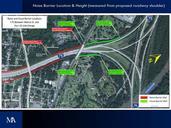
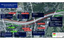
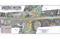
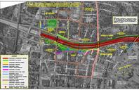
Keywords from Image Description:
outdoor An aerial map showing the improvements planned for the Pleasant Hill neighborhood part of the Interchange Improvement project. An aerial map showing the improvements planned for the Pleasant Hill neighborhood part of the Interchange Improvement project.