
Related Images


Download:
| Tiny | 123x128 | View | Download |
| Small | 246x256 | View | Download |
| Medium | 492x512 | View | Download |
| Original | 600x624 | View | Download |
This image was acquired from
wikimedia. It was marked as Public Domain or CC0 and is free to use. To verify, go to the source and check the information there.
Looking for more info about this image?
Try a Google Reverse Image Search for it.
Try a Google Reverse Image Search for it.
Keywords from Image Description:
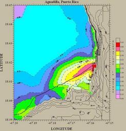
Inundacion. From en Original information December Thief Talk contribs Simulation of the Puerto Rico tsunami showing calculated inundation of the Aguadilla coast in northwest Puerto Rico Heavy black line coast line noaa gov html Image courtesy of USGS PDUSGov History of Puerto Rico Earthquake maps