
Related Images


Download:
| Tiny | 101x128 | View | Download |
| Small | 203x256 | View | Download |
| Medium | 407x512 | View | Download |
| Original png | 700x879 | View | Download |
| Original as jpg | 700x879 | View | Download |
This image was acquired from
wikimedia. It was marked as Public Domain or CC0 and is free to use. To verify, go to the source and check the information there.
Looking for more info about this image?
Try a Google Reverse Image Search for it.
Try a Google Reverse Image Search for it.
Keywords from Image Description:
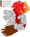
rorszg beteleptse angol telepesekkel. en This map highlighting the areas subjected to British plantations in Ireland Although the plantations in Munster did not cover the entire shaded area it has been simplified for the purposes of this map Modern county boundaries are also shown hu trkp az angol telepesek beteleptsnek temezst mutatja