
Related Images


Download:
| Tiny | 185x128 | View | Download |
| Small | 371x256 | View | Download |
| Medium | 743x512 | View | Download |
| Large | 1486x1024 | View | Download |
| Original | 1767x1217 | View | Download |
This image was acquired from
wikimedia. It was marked as Public Domain or CC0 and is free to use. To verify, go to the source and check the information there.
Looking for more info about this image?
Try a Google Reverse Image Search for it.
Try a Google Reverse Image Search for it.
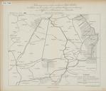
Keywords from Image Description:
KAARTEN SGD Veranderingen hoog water in cm ten gevolge van verruiming Dordtsche Kil.jpeg accession number en The individual creators of this map are unknown it was commissioned by the House of Representatives of the Netherlands Uitgegaan wordt van een Qbr Bovenrijnafvoer van help warp This map was digitized by the Institution Koninklijke