
Related Images


Download:
| Tiny | 234x128 | View | Download |
| Small | 469x256 | View | Download |
| Medium | 939x512 | View | Download |
| Original | 1183x645 | View | Download |
This image was acquired from
wikimedia. It was marked as Public Domain or CC0 and is free to use. To verify, go to the source and check the information there.
Looking for more info about this image?
Try a Google Reverse Image Search for it.
Try a Google Reverse Image Search for it.
Keywords from Image Description:
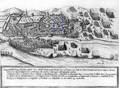
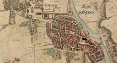
Kempten ReichsstadtFrststift . en Section of an cadastral map of Kempten with the blue line representing the old border between the Protestant Free Imperial City and the Catholic Princely Abbey of Kempten before the two entities were annexed by Bavaria in As can be seen the grounds of the princeabbot's palace Residenz almost touched