
Related Images


This image was acquired from
wikimedia. It was marked as Public Domain or CC0 and is free to use. To verify, go to the source and check the information there.
Looking for more info about this image?
Try a Google Reverse Image Search for it.
Try a Google Reverse Image Search for it.
Keywords from Image Description:
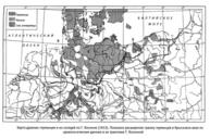
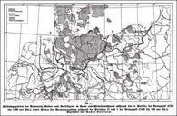
Kossinna map. de Siedlungsgebiete der Germanen Kelten und Nordillyrier in Nord und Mitteldeutschland whrend der II Periode der Bronzezeit bis vor Chr sowie Grenze der Germanengebiete whrend der Perioden III und der Bronzezeit bis vor Chr ucm es htm Gustaf Kossinna PDOld Gustaf Kossinna Maps of European Bronze and Iron Age