
Related Images


Download:
| Tiny | 149x128 | View | Download |
| Small | 298x256 | View | Download |
| Medium | 597x512 | View | Download |
| Large | 1194x1024 | View | Download |
| Original | 1600x1372 | View | Download |
This image was acquired from
wikimedia. It was marked as Public Domain or CC0 and is free to use. To verify, go to the source and check the information there.
Looking for more info about this image?
Try a Google Reverse Image Search for it.
Try a Google Reverse Image Search for it.
Keywords from Image Description:
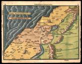
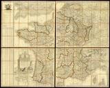
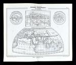
Les Principaux Systemes Geographiques des Anciens. en The Principal Geographical Systems of the Ancients single plate containing four inset maps depicting the world as known to Homer Eratosthenes Herodotus and Ptolemy Drawn by Vuillemin engraved by Erhard DouguayTrouin and printed by Dufrenoy at Paris fr Les Principaux Systmes Gographiques