
Related Images


Download:
| Tiny | 196x128 | View | Download |
| Small | 393x256 | View | Download |
| Original png | 492x320 | View | Download |
| Original as jpg | 492x320 | View | Download |
This image was acquired from
wikimedia. It was marked as Public Domain or CC0 and is free to use. To verify, go to the source and check the information there.
Looking for more info about this image?
Try a Google Reverse Image Search for it.
Try a Google Reverse Image Search for it.
Keywords from Image Description:
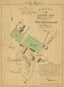
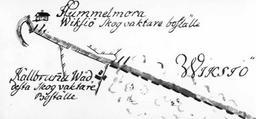
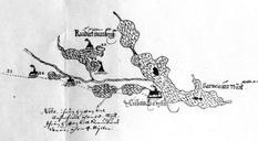
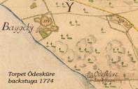
Lidingsberg . sv Det ursprungliga torpet dalsnkan vid Lidingsberg Liding dokumenterad en karta frn benmnt deskure backstuga Vid torpet fanns ingen uppodlad mark Torpet lg inom lantbruksgrden BaggebyBodal som utgjorde en gemensam lantbruksfastighet med tv separata grdsenheter Map of Liding created by Kiezling updated by Boding Kiezling